
 When I was 12, my father ordered a 30-foot Chris Craft cabin cruiser to be christened Jaunty June in honor of my mother who, as it happened, never much enjoyed life on a boat. For me the boat became a ticket to summer adventures from New York City to Maine by sea and to Canada by Hudson River, Lake Champlain, and upstate canals and locks. While waiting for his boat, my father nearly memorized Chapman’s Piloting & Seamanship proudly telling me of his mental prowess and giving a lesson he was willing to share with his eager son: “East is least and west is best, un-correcting.” I always remembered, but never understood, what that meant until after his death when I studied navigation during the year Celtic Song was being built in Orange County. Finding North by the North Star (Polaris) is easy. Look up in the night sky. The North Pole is located directly below Polaris. There lies North. This works in the Northern Hemisphere for the period from Shakespeare’s time through the 21st century. In 3,200 years, a new pole star will be needed because of the precession of the Earth’s axis (wobbling like a top). See these links for reference: If you sail south from the Northern Hemisphere, night by night you will see the height of Polaris fall towards the horizon until it disappears as you pass over the equator. That’s what I saw on a voyage from Puerta Vallarta, Mexico to Hiva Oa of the Marquesas in French Polynesia. On any clear night in the Northern Hemisphere, you can estimate latitude by observing the angle of Polaris above the horizon. At 90 degrees, you are at the North Pole. At zero degrees, you are somewhere on the 24,901-mile equator. After you pass over the equator to the Southern Hemisphere, you find the South Pole by using the Southern Cross. You can research that and teach it to me. When you know where north is, you can hold a circle of directions (known as rose of the winds or compass rose) parallel to the sea with the line marked north pointing to north so that by looking at the circle you can see which way lies every other direction (east, south, west). 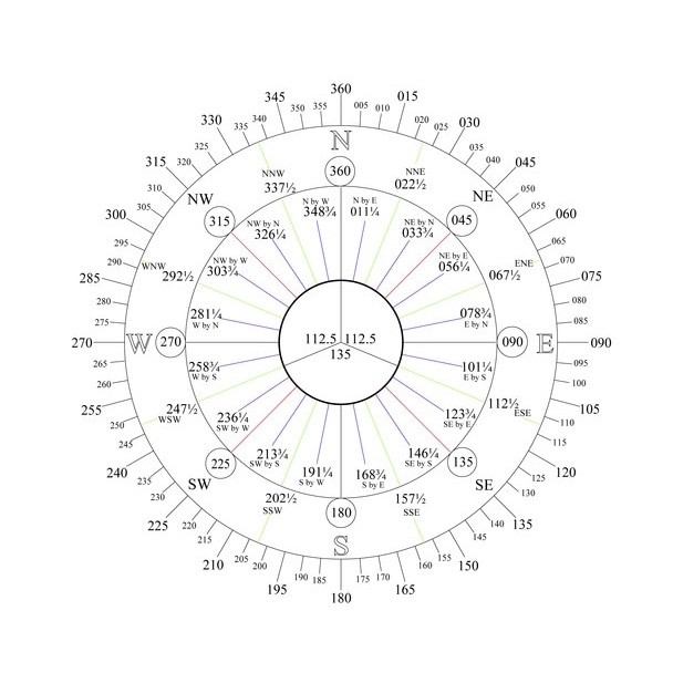 Celtic Song compass rose Celtic Song compass rose In the accompanying compass rose that I created for Celtic Song, 112.5 degrees represents the angle in which the green starboard navigation light shines from dead ahead to “two points abaft the starboard beam.” With 32 points in 360 degrees, each point is 11.25 degrees. Starting from dead ahead, the starboard beam sits at 90 degrees. Two points more add 22.5 degrees giving an angle of 112.5 degrees. Today the COLREGS use the phrase “22.5 degrees” in nine places. Why an angle in fractional degrees? Because the rule’s angle remains constant while the unit of measurement has changed from points to degrees. Also, after subtracting 112.5 degrees on starboard and 112.5 on port, 135 degrees remain across the stern. This is the angle of white stern light. It is the angle an approaching vessel is, under the COLREGS, an overtaking vessel. I always keep the Celtic Song compass rose on the navigation desk to help translate a bearing from a number of degrees (as received from the AIS) to a graphic bearing line on the chart plotter or on a paper chart. The AIS is True North Up; it gives bearings in True only -- not magnetic. So for consistency, the chart plotter at the Nav Station must stay set for True North Up. Paper charts are also True North Up.
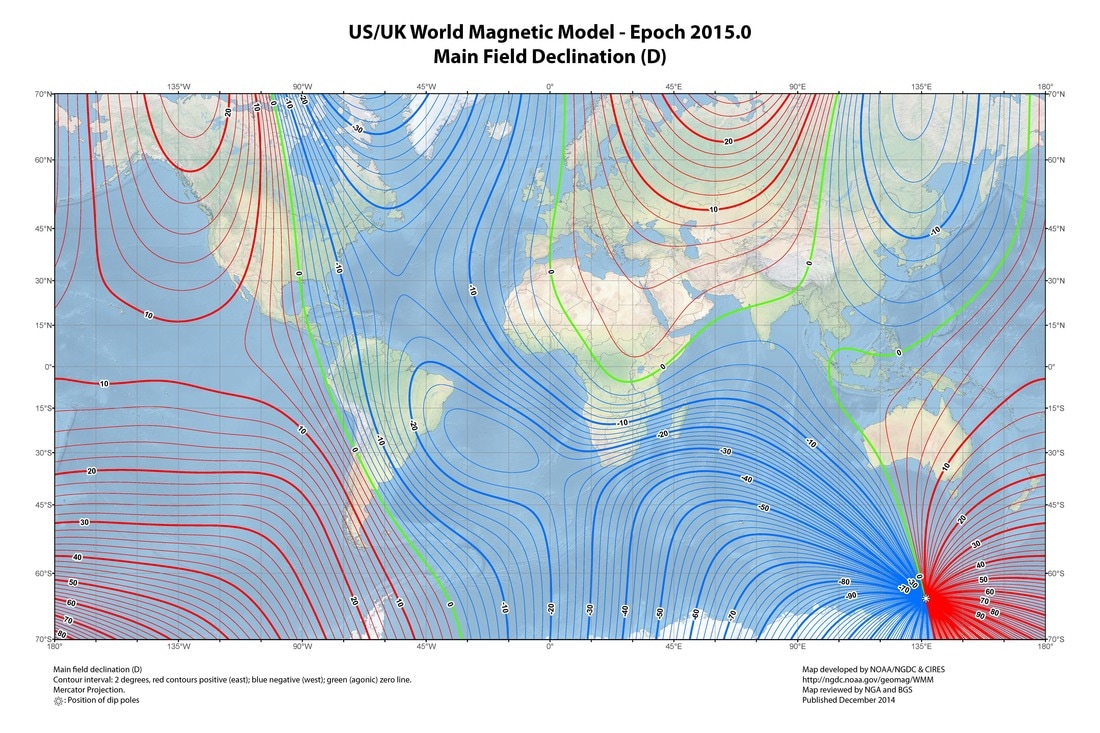
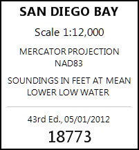
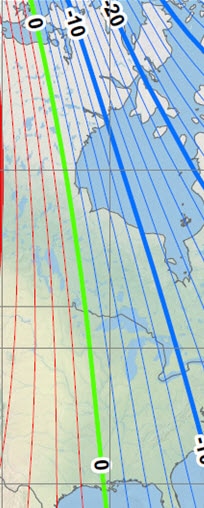
Let’s focus on a portion of the world shown in the upper right. The magnetic 12 east variation line (red thin above red bold) runs approximately through San Diego and the Aleutian Islands. The 20 east variation line (red bold) touches down to the Gulf of Alaska north of Glacier Bay. The zero variation line (green) cuts through the Midwest of the U.S. running into the Gulf of Mexico at about New Orleans. The 10 west variation line (-10 blue bold) cuts into the Eastern Seaboard in the Mid Atlantic states. Now let’s go from the big picture to greater precision. What was the magnetic variation of the Harbor Island Fuel Dock on Jan. 1, 2017? Three methods for answering: (1) Paper chart. (2) Calculation from model using a web site (3) Computer software For the paper chart method, start with the correct chart:
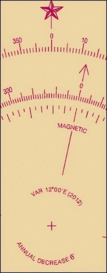
Look at the portion of its compass rose (upper right) where it says: VAR 12°00’ E (2012) Annual Decrease 6’ In about 5 years, at 6 minutes of angle a year, the decrease is 30 minutes of angle — 30 divided by 60 or 0.5 degrees of angle. So the variation in San Diego on Jan. 1, 2017 is about 12 degrees East minus 0.5 degrees East or 11.5 degrees East. For the calculation from model method, start with this web site: Enter latitude and longitude of Harbor Island fuel dock and date of Jan. 1, 2017 and receive the answer of “2017-01-01, 11.61° E ± 0.33°” using the year 2015 World Magnetic Model. Or get the world declination software and make the calculation without an internet connection. The result is the same. Remember that positive declination is East Variation and negative declination is West Variation. 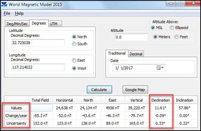 On the West Coast, Magnetic North lies to the East (right) of True North, and on the East Coast, Magnetic North lies to the West (left) of True North.
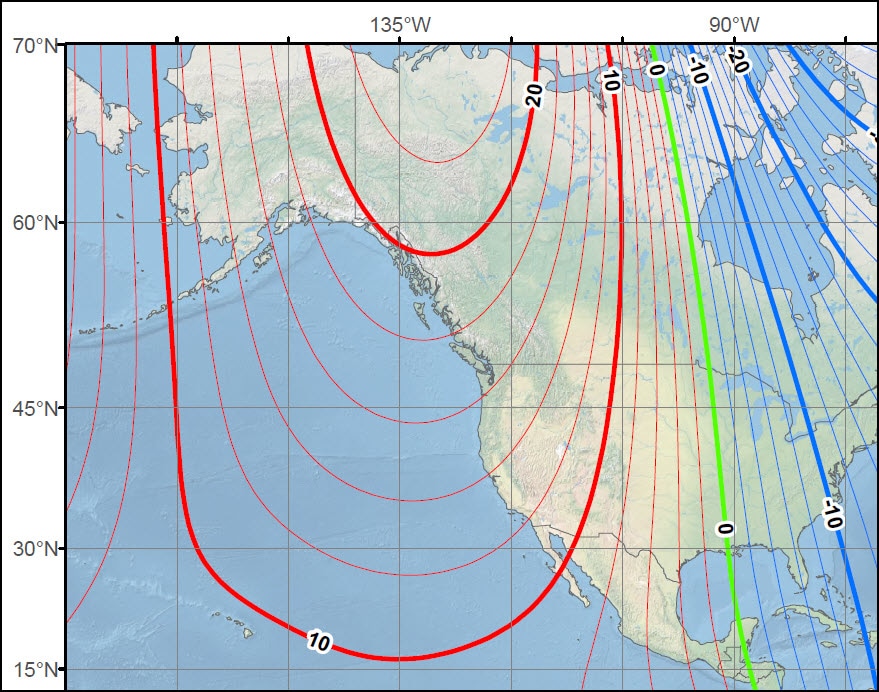
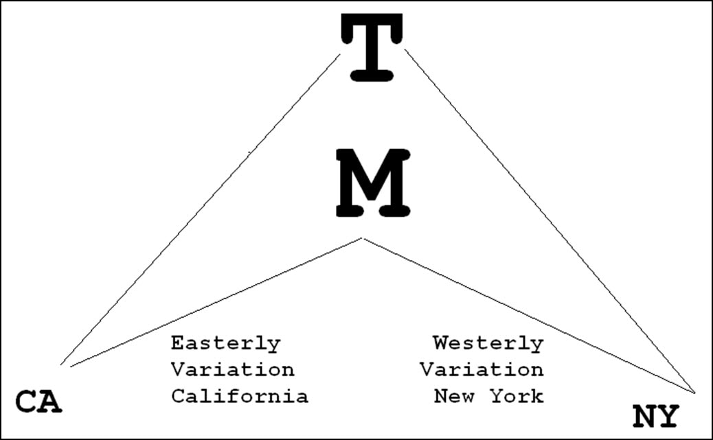
If this seems strange, look at the slice of world magnetic model (below left) and notice the green line running north and south through the Midwest of North America. In the diagram below right, imagine that T is the (true) North Pole and M is a place south of the North Pole on that green line. Think of M as a place toward which compasses in the U.S. point. A compass on the West Coast points to M along a bearing which is to the east of a bearing to T. A compass on the East Coast points to M along a bearing which is to the west of a bearing to T
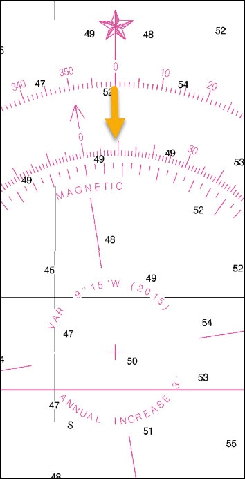
What might be confusing is that the compass rose on paper charts is actually two separate circles of directions. The outer circle has the zero degree line (5 pointed star) pointing to True North. The inner circle is the compass rose with the zero degree line (arrow) pointing to Magnetic North. Consider those two separate circles. In San Diego (East Variation), if you start with True North at 0 degrees (same as 360) to “un-correct” to get the Magnetic equivalent of the same direction, you must subtract 12 from 360 to get 348 Magnetic shown by the green arrow below. At Cape Fear (West Variation on East Coast) you must add 9 to True North 0 to get the the magnetic equivalent of the same direction.
In San Diego, determine your desired course on a paper chart in True and then subtract 12 to get the same magnetic course to steer. If the helms person uses the compass to give you a bearing in magnetic, add 12 to get the same direction in True for paper chart plotting. You also must make an adjustment for compass error which may be different for each direction. This is called deviation. For Celtic Song, I had a professional swing the compass and prepare the deviation table which is kept at the Nav Station. The amount of deviation is so small that adjustment for it is unnecessary. The rule — T-v-M-d-C, add West — which is memorized as “TV makes dull children , add work” means that as you un-correct from True to Compass, you add for west variation and west deviation while you subtract for east variation and east deviation. That’s what my father taught me at age 12: East is Least and West is Best, un-correcting. Obviously nothing is incorrect about a magnetic bearing, but the rhyme makes it easy to remember the mechanics of conversion from one point of reference to another.
1 Comment
Hal
3/23/2017 12:50:11 pm
All true ... but can you find South using the Southern Cross and the Pointer stars? ;) Leave a Reply. |
From the admiral's chairJohn Berol is the husband of Captain Diane. He commissioned Celtic Song in 2005, has sailed extensively and maintains an active interest in both the boat and her captain. He believes the more you know, the better you will sail. The term “Admiral’s Chair” is a family joke. For just as every writer needs an editor, so every captain needs an admiral. Archives
March 2021
Categories |


 RSS Feed