|
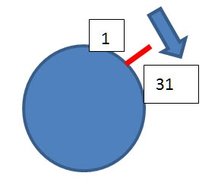
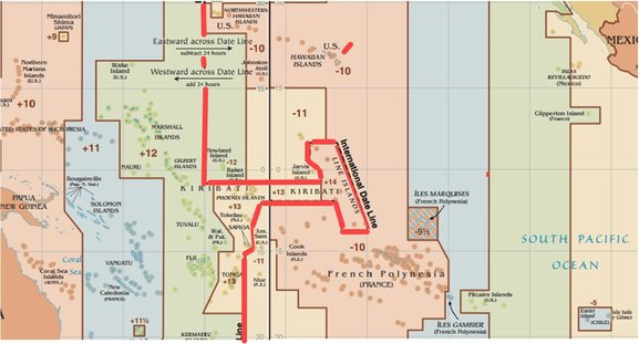
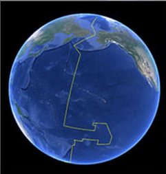
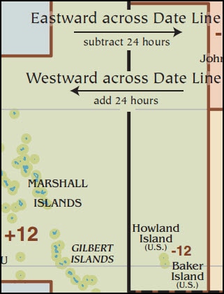
Time Passes, To the Lighthouse by Virginia Woolf “I got such a fright last night,” replied Dantès, smiling, “that I have almost lost my memory. I ask you what year is it?” The Count of Monte Cristo by Alexandre Dumas I have measured out my life with coffee spoons, The Love Song of J. Alfred Prufrock by T. S. Elliot We may not know what time is, but from a “big date” to finding ship’s position, we reckon it with care and precision. Knowing time remains as essential to getting GPS position in the 21st century as it became for finding longitude at sea in the 18th century. Short explanation of 21st century GPS clocks Longer explanation. For the 18th century, see Longitude by Dava Sobel There is a simpler way. Stay in one place. As the world turns, days pass by. This is our starting atavistic expectation of time. But, get in a plane during the day, fly west at the speed of the earth’s rotation (about 1,000 mph at the equator), and the sun will never move from your sight. All easting and westing, at any speed, distorts the opportunity to measure time through the observation of the sun. After a westward circumnavigation of the earth, Magellan’s crew was surprised to find when comparing ship’s log with home calendars, that they had lost a day. Upon completing his easting Around the World in 80 Days, Phileas Fogg was surprised to find he had gained a day. This is not about Einstein’s Theories of Relativity, but it is about relative motion. As a child my father perplexed me by saying that if one traveled west faster than the sun then one would go back in time. I knew this was false, but I did not know how to prove it. I observed that moving westward on a train, I had to periodically set my watch back an hour and, each time, that made my day an hour longer. I wondered what would happen if one kept this up forever. --------------------------------------------------------------------------------------------------------------- NOTE: Relative motion matters to boaters because this is what they focus on when determining whether the constant velocity (course and speed) of one vessel and that of another will put them in the same place at the same time. This is why it is wrong (potentially leading to unlawfully dangerous action) to think of any vessel as having “right of way.” The correct term, with completely different meaning, is “Stand-on” vessel (as defined by 72 COLREGS – Navigation Rules) which has a legal duty to “keep her course and speed” until released from that duty or required to act differently to avoid collision (as defined by the COLREGS). Why? Because unless the “Stand-on” vessel fulfills her duty to keep her course and speed (while it is still safe to do so), it becomes difficult or impossible for the “Give-way vessel” to calculate what she needs to do to avoid collision. See movie LA Story where four cars at four-way stop first all try to politely be the give-way car and then all decide simultaneously to be the go-ahead car. -------------------------------------------------------------------------------------------------------------- Returning now to time. What befuddled Fogg and Magellan was their failure to consider their own motion relative to the sun’s apparent motion. Imagine a world without the conventions of time zones and International Date Line. If you leave at noon circumnavigating westward at the speed of the sun, you will be at noon the whole trip but when you get home, your village will have seen noon pass by and return. Their calendar will be a day later. At any speed, you gain hours of sun as you travel west. You can return home either by going east or by continuing west for a circumnavigation. With an easterly return you give up all the hours gained while westing. With circumnavigation you gain 24 hours of sun time and periodically set your watch back to coordinate its noon with when the sun is overhead. Your journey calendar will end up 1 day behind the calendar of your home. If you do not like the math, think of it as only fair. You gain hours traveling west so at some point you have to give them back. That can be done by losing a day. The opposite when traveling east, you lose hours and at some point you get them back. What is the “some point” referred to above? There must be a reckoning for a day, but the math does not care where that is done. You could wait until you get home or you could do it when halfway around the world. Here is another way to grasp the problem. Look down on the earth from above the North Pole. Notice how midnight circles the earth every 24 hours, wiping away the old day and painting on the new one. At all times, it is midnight somewhere with a different day on each side of it. Face north, make a fist with your left hand with thumb on top and imagine how the apparent motion of sun (and thus midnight) travel from right to left (westward) as though from New York to California. Now rotate your fist 90 degrees towards you and note that the apparent motion of sun about the earth is clockwise as seen from above the North Pole looking down. (Looking down from above the South Pole the apparent motion is the opposite.) In the figure below, the red line on the equator (and all other parallels of the globe) represents midnight which rotates east to west (clockwise) about the equator as seen from above the North Pole. Before midnight passes you, it is New Year’s Eve. After midnight passes it is New Year’s Day. But there is a problem. We need another line somewhere, anywhere, so there can be two boundaries to contain each of the two dates. The math would be happy to have the line anywhere, as long as it is defined. It has been found convenient to put the line halfway around the world from Greenwich, England in an area which is mostly ocean. It is called the International Date Line. It is not really international in that every jurisdiction has freedom to declare any date they like for their country. The so called “line” is free to zig and zag and even encircle countries as they decide what date they want to use. Kiribati changed its date so as to be first instead of last to greet the new millennium. That resulted in its having a new time zone of +14 instead of its old time zone of -10. Note the difference is 24 hours which makes for 1 day. Note the extent to which the line deviates from the 180 degree meridian. Where the dateline behaves normally, the instructions below will suffice. Eastward subtract 24 hours. Westward add 24 hours. The line itself is not needed. It is easier to convert time zones. The Marshall Islands are Zone +12. Baker Island is Zone -12. To go east from +12 to -12 there is a total change of -24. That results in setting the calendar back 1 day and gaining 1 day when going eastward. In the opposite direction from -12 to +12 there is a total change of +24. That results in setting the calendar ahead 1 day and losing a day when going westward. Suppose it is 1 pm in San Diego (Zone -8) on Monday. You want to know the date and time in the Kiribati Line Islands (Zone +14). Do the time zone conversion and the date will follow. From -8 to +14 is a change of +22. So add 22 to 1 pm. Do this in 2 steps. Add 11 hours to get to midnight and thus the next day, Tuesday. Then add 11 more hours to get to 11 am on Tuesday. Before the date line change, the Kiribati Line Islands were in Zone -10. From -8 to -10 would have been a reduction of 2 hours from 1 pm to 11 am on Monday. Wikipedia points out that it is possible to simultaneously have three different dates in the world. This is because of the bending of the so-called date line. The best method to calculate is again by time zone difference while forgetting about date line. Calculate as follows: Start with 10:01 am on Thursday at UTC (Zone 0, Greenwich, England). Find time in American Samoa (Zone -11). From 0 to -11 is a change of -11 which is 11:01 pm Wednesday because in subtracting 11 hours from 10:01 am, we pass backwards over midnight. Find time in Kiribati, Line Islands (+14). From 0 to +14 is a change of +14 which is 12:01 am Friday because in adding 14 hours we pass forward over midnight. See “Facts dependent on the IDL” section of Wikipedia, International Date Line Here are some steps to keep things straight when converting between time zones:
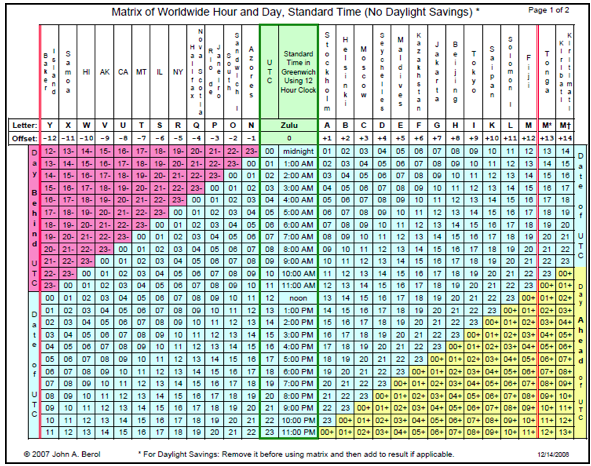
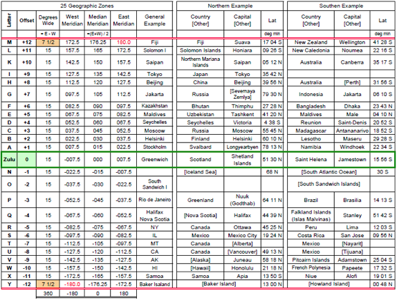
Click here for a 2 page chart. Page 1 permits calculations by table. Page 2 gives examples of time zones. Example calculation: Convert April 29 at 5:01 pm San Diego to Fiji date and time. Look on page 2 and see that San Diego is Zone -8 (U) and Fiji is Zone +12 (M). Start with 5:01 pm DST and subtract 1 hour to get 4:01 pm standard time. Add 12 hours for 24 hour time of 1601. Find 16 in column for zone -8 (U). It is marked as 16- in pink to show it is a day behind UTC which means UTC is a day ahead of it. Look to right in UTC column and see it is “00 midnight.” Therefore April 29 at 5:01 pm DST in San Diego is April 30 at 0001 UTC. Keep in this same time row going right to the column of +12 (M) Fiji and find 12. Therefore Fiji in standard time is 1201 or 12:01 pm. Look on Page 2 to see that Fiji is below the equator (lat. 17 deg. s) so it has winter when San Diego has summer. Internet search confirms hunch that Fiji does not have Daylight Savings Time on April 30, so the answer remains as 12:01 pm on April 30. Internet confirms this is correct, but no internet or computer is needed with the 2-page chart available here for printing with the permission of author. Consider again the 10:01 am example shown by Wikipedia when there are three dates in the world at the same instant. This can be seen on Page 1 of the above chart by looking at 10 am UTC and noting that at that time it is 1 day earlier (pink 23-) in Zone -11 (X) and 1 day later (yellow 00+) in Zone +14 (M †). This only happens because of the new times zones +13 and +14. The result is that the date line is no longer as simple as adding or subtracting 1 day. If it were 11:01 pm in America Samoa (Zone -11), and you were able to jump in 10 minutes to Kiribati (Zone +14), your watch would read 11:11 pm. Then you would need to advance your watch and calendar by 25 hours putting you at the hour of 11 minutes after midnight two days later. One day for the movement past midnight and 1 day because Kiribati advanced itself ahead a day from what would be expected by a normal date line. Accordingly, the International Date Line is none of the three things implied by its name. It is not international because time is decided by local politics. It is not a single date change because in theory there could be a 2-day change when crossing. It is not a line because it zigs and zags and potentially could be discontinuous according to the whim of localities. But you still must change your ship’s calendar at some point when circumnavigating the globe. ADDENDUM TO MEASURING TIME Mathematician David Darling explains “there’s no way to continuously map points on a real number line onto a circle” as shown by “the “Borsuk-Ulam theorem in one dimension.” “The International Date Line is needed ... (because it) takes care of the inevitable discontinuity by having it happen all at once, as a jump by one whole day, on a longitude that passes mostly through open water in the Pacific.” The Universal Book of Mathematics: From Abracadabra to Zeno's Paradoxes by David Darling. Here is a video explanation of that theorem. The part about temperature (single dimension) is relevant. The video shows that on an instantaneous trip about the equator, assuming that temperature change from point to point is continuous, then there must be two antipodal points with the same temperature. Two antipodal points are defined as diametrically opposed points which means points connected by a diameter which means points connected by a line running through the center of the earth. I would welcome any reader to check and expand my following understanding of the above. We want two things from our time system:
These two wants create a continuity which can not work on a circle in which any circumnavigation starts and ends at the same point of a circle. A discontinuity must be introduced. The Time Line does so. While there must be a discontinuity, it need not be a line drawn on the map. The system of times zones flowing as +1, +2 to +12 in one direction from the Prime Meridian and -1, -2, to -12 in the other direction automatically create the necessary discontinuity. Movement between the neighboring -12 and +12 zones creates a discontinuity of a time zone change of 24 hours. In all other movements between time zones the time zone change is 1 hour. We could go to 48 zones of 30 minutes each with -24 and +24 as neighbors. There would still be a difference between these discontinuous neighbors equal to 48 times 30/60 which is still 24 hours. Or go to times zones as small as you like and the discontinuity would still be handled as 1 day of 24 hours. USE UTC We need agreement on time to navigate and coordinate activities including rescues. See UTC as a great convenience and safety mechanism rather than an irritating strange number for converting to local time. Ships should keep a clock set to UTC or at least keep in their log the difference between their current settings of GPS devices, watches, clocks etc. and UTC. There is possibility of trying to have extra safety with several GPS devices, but they are all inadvertently programed for different local times. HAVE A MEANS TO ALWAYS KNOW UTC There is no other way to assure coordination between you and the world outside your ship whether that be a rescuer or navigation by celestial objects. UTC is simple. Everyone agrees on what it is. It flows second by second in only one direction. There are no time zone shifts and no date shifts to make mistakes with. Local time can take care of itself. When you stop on an island, you can ask locals what they are using for date and the time. For all you know they might have changed their clocks and date by a new law passed while you were at sea. If you lose track of UTC, that could be a big problem. You do not really need to know local time until you are catching an airplane home. Then you can ask. WHAT IS UTC? UTC stands for Coordinated Universal Time. It is our primary time standard, not a time zone. It happens that when people in Greenwich, England are not using Daylight Savings Time, then their time zone (0 or Z or Zulu or GMT) has the same time (as a practical matter) as UTC. UTC gets adjusted by a second from time to time to coordinate with the sun. Other time standards may not do this so as to keep them simpler and more consistent. Time is always measured by repletion of cyclic events. The cycle of the earth’s rotation, the cycle of the moon, the ticking of a clock, the swing of a pendulum, the hum of a tuning fork. UTC is maintained by observing the resonance frequency of the cesium atom. HOW TO USE UTC When you need to communicate with others about the world, coordinating your plans by UTC is the easiest way to avoid making a computational error. To convert to local time and date, add or subtract the local zone and then if applicable add 1 hour for daylight savings.
1 Comment
|
From the admiral's chairJohn Berol is the husband of Captain Diane. He commissioned Celtic Song in 2005, has sailed extensively and maintains an active interest in both the boat and her captain. He believes the more you know, the better you will sail. The term “Admiral’s Chair” is a family joke. For just as every writer needs an editor, so every captain needs an admiral. Archives
March 2021
Categories |

 RSS Feed